
Palm Desert Neighbors Lookup Basics
A block lookup in Palm Desert uses several official and community channels. Map My County supplies the parcel layer. The Riverside Assessor connects a known address or APN to available roll details and provides the office procedure for owner information. The recorder index can show recorded parties after the parcel gives a useful name clue. Permits can date work at a nearby address. Voter status is a self-only tool, and an authorized voter-file request is limited by purpose and security rules.
| Source | What it shows about a block | Access |
|---|---|---|
| Map My County parcel layer | Shapes, adjacency, APNs, tract links, and legal geography | Free map and parcel reports |
| Riverside Assessor | Parcel facts and the permitted owner-information route | Free address, APN, or PIN search; office procedure for owner |
| Riverside Recorder | Recorded party and title-chain clues for selected parcels | Free name index from 1974; paid copies |
| Palm Desert permits | Project address, APN, applicant, scope, and date clues | Clariti or Development Services request |
| Voter information | Self-status or controlled fields for an approved purpose | Not a public block browser |
| Community material | Public contacts, board rosters, or association boundaries | Published channel or association request |
These sources can describe the block without identifying every person on it. A useful neighbor note says “adjacent parcel,” “recorded owner,” “public board member,” or “permit applicant,” rather than using the broad word neighbors for every result.
Palm Desert Neighbors and Parcels
Start with one known address in Riverside Map My County. Zoom until parcel lines display, select the target polygon, and save the APN and parcel report. Pan to the polygons that touch or sit near the target. The viewer can also use cross streets, cities and communities, legal description, assessor book and page, permit and case, and address search controls. A list of APNs can be submitted for a multi-parcel report.
Map My County documents pan, rectangle zoom, measurements, drawing, print with title and legend, image export, query, and filter tools. Use those controls to mark a block or a short radius. There is no documented public automatic resident-radius tool. Each selected parcel needs its own official lookup and its own source note.
The Riverside GIS viewer is the source for the parcel method used below.
Address → target polygon → APN list → parcel reports → assessor and recorder checks.
The flow keeps a map relationship distinct from a person conclusion. Nearby parcels can belong to different tracts, communities, city limits, or postal areas.
Palm Desert Neighbors' Parcel Clues
An adjacent polygon tells you that two parcels touch or sit within the selected map view. A parcel report can add APN, assessor map, tract link, city or community context, cross streets, legal-description search context, permit and case links, and a printable map. These are strong geography clues. They do not identify every occupant, delivery recipient, household member, or person who spends time at the address.
Seasonal ownership adds another Palm Desert caution. A property owner, winter club member, business officer, registered voter, and year-round occupant can have different connections to the city. An adjacent parcel is a place. A recorded deed is a party role. A permit is a project. A voter status result belongs to the person who authenticates it.
- Parcel polygon
- The selected land has a mapped relationship to the target view.
- APN or tract link
- A durable key for a separate county search.
- City or community label
- A geography clue that still needs jurisdiction confirmation.
- Permit case link
- A project or land-management clue, not a household record.
Palm Desert Assessor Clues
Riverside's public property search is designed to find an APN, PIN, or property address. It does not display an open owner-name search. Map My County labels Parcel Owner as county use only. When owner information is needed, the documented path crosses from the online parcel search to an assessor office or public-roll procedure. Repeat that process for each nearby APN rather than treating one owner result as a block roster.
The tax-bill sample distinguishes the situs or physical address from the owner's mailing address. A mailing destination can point to a different city or agent. It does not prove that the owner lives at the parcel, and the parcel roll does not list every occupant. Keep those limits in the neighbor worksheet.
Use the Riverside Assessor search for each address, then follow the county assessor office information for the permitted owner route.
Palm Desert Neighbors and Voter Limits
California My Voter Status lets a voter inspect their own record after an identity-authenticated name, birth date, and identifier match. It cannot browse Palm Desert neighbors by name, street, ZIP, or block. A separate voter-file application can request controlled data only for approved election, scholarly, journalistic, political, or governmental purposes. The application asks for a purpose, jurisdiction, security plan, supporting affiliation, and permitted-use agreement.
California Elections Code protects home street address, phone, email, precinct number, prior registration information, signature, driver license or state ID number, and Social Security number. The regulations distinguish a specific identified voter from an unidentified group such as voters on a Palm Desert street. Casual block research is not the approved route.
The California Elections Code section 2194 is the source for the restrictions reflected in the image.
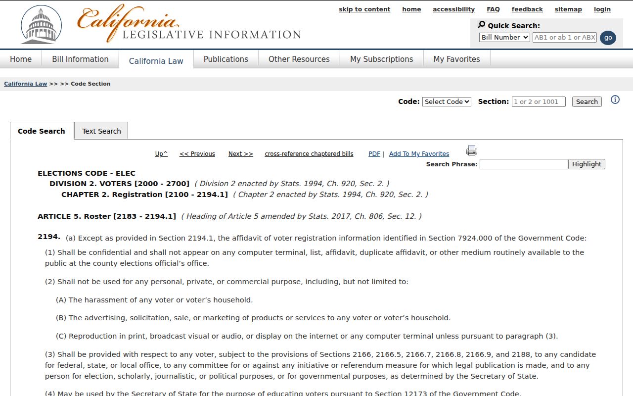
The statutory access screen reinforces why a neighbor lookup must use parcel and public community clues instead of a voter-name list.
Palm Desert Community Organizations
Public community material can help explain a Palm Desert block, but the assigned sources did not verify a city-recognized neighborhood-association umbrella or a public member directory. A public board roster, planning-area record, contact page, or archive newsletter is a community clue. It is not permission to publish a private association list.
| Community or group | Verified local connection | Directory status |
|---|---|---|
| Palm Desert Greens and Portola Country Club | City Development Services identifies these mobile-home communities for city permitting service | No public resident or member directory verified |
| Ironwood Estates Association | Named in a Palm Desert staff report as a registered HOA | No public member directory verified |
| University Neighborhood area | Planning geography near the CSUSB and UCR campuses | Not a membership roster |
| Millennium and Refuge specific-plan areas | Official planning areas with acreage and development context | No resident directory verified |
| City boards and commissions | Granicus pages may publish official civic-body members | Public civic roster, not a block roll |
Ask an association about its public contact or governance channel when there is a lawful reason. Do not assume a private HOA roster, congregation list, club list, or block-watch list is open merely because the group has a public website.
Palm Desert Neighbors, HOAs, and Edges
Development names, association boundaries, postal ZIPs, and city limits overlap imperfectly in Palm Desert. 92260 and 92211 are core delivery codes, while 92210 sits near Indian Wells and the southeast edge. University Neighborhood, Millennium, Refuge, country clubs, and private streets can be useful place clues without being legal or civic boundaries.
Mobile-home permitting shows the jurisdiction issue clearly. Palm Desert provides city service for Palm Desert Greens and Portola Country Club, while other mobile-home permitting goes to California HCD. A neighbor search should verify the parcel and custodian before sending a permit, records, or association question to the wrong office.
The Palm Desert General Plan gives the local geography and planning context. For an exact address, pair it with Riverside GIS and USPS.
Palm Desert Owners, Occupants, and Mail
A neighbor worksheet should use distinct labels for the person named in a deed, the owner listed in an assessment record, the applicant in a permit, the recipient at a mailing address, and any historic occupant in a directory. Those roles can belong to different people. A recorded transfer can involve a trust or entity. A permit can name an agent or contractor. A seasonal owner can have a mailing address outside Palm Desert.
| Source type | Official record trail | Private or commercial category |
|---|---|---|
| County parcel and deed | APN, legal description, recorded party, document date | May merge names or lag; not a source for correction |
| City permit or civic roster | Project contact, board member, or public role | May collect public-facing affiliations outside the parcel |
| Community contact | Published boundary, board, or request channel | Private member data is not assumed public |
Commercial neighbor products compile mixed data and can merge people, omit protected households, or lag behind official changes. The official category is narrower but traceable. Use the record custodian when a source must be corrected.
Palm Desert Neighbors and District Maps
Palm Desert adopted five single-member City Council districts on January 25, 2024. The district locator can connect an address to a council district. That result tells you which civic geography surrounds the parcel. It does not identify the neighbors, prove registration, or show who attends a meeting. A City Clerk request can supply public agendas, minutes, appointments, resolutions, ordinances, and other municipal records when a public role or action matters.
For block research, a district map is most useful after GIS has resolved the address. Keep the district result with the parcel APN and date, because municipal boundaries and planning areas can change while a deed's legal description remains the land key.
Palm Desert Neighbor Lookup Limits
Protected residents, sealed court records, DMV data, utility customers, delivery recipients, and household members do not become public because a parcel is adjacent. California Safe at Home can use a substitute address for eligible participants and does not promise that every old record disappears. Voter data carries purpose limits. Recorded documents may have sensitive fields redacted under specific rules.
If the public trail ends, accept that limit. Use the City Clerk for a focused municipal request, Development Services for a permit file, the assessor office for the documented roll procedure, the Recorder for a deed copy, and a community organization only through a public contact channel. Do not convert a gap into a guessed person or address.
Lawful use. Palm Desert neighbor research can support civic awareness, family history, estate work, and safe, consensual reconnection. Never use a block trail to stalk, harass, intimidate, or harm anyone.
The Palm Desert street directory route is the right handoff when the goal changes from one block to the full street-by-street parcel chain.